Download International Version:

![]()
Download CERT Version:
![]()
Download US Domestic Version:
![]()
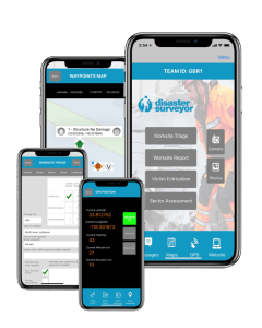
USAR Data Collection App and Team Management Website
Disaster Surveyor makes today’s urban search and rescue field data collection and reporting process efficient and centralized. Our web-based disaster management tools give team leaders the ability to view all in-progress work to gain real time situational awareness.
- NEW PREMIUM FEATURE: SMS-based team dispatch
- NEW PREMIUM FEATURE: SMS-based Team Messaging
- NEW PREMIUM FEATURE: Post Waypoint Data to any ArcGIS Online Feature Layer for Operations Dashboards
- NEW PREMIUM FEATURE: Archiving of Forms, Tracks, Waypoints and viewing by date range
- Master account to view all in-progress work to gain real time situational awareness while waiting for official vetted information to be submitted via current information exchange process.
- Expedited information download: Crews can upload information to the base of operations from the field in real time.
- Base technical information personnel can download GPS coordinates in multiple formats to include the INSARAG forms, vet information and upload to UCC (USAR Coordination Cell).
- Ability for commander to view last known locations of teammates
- International language support website dashboard and Spanish version app UI support
- In app team messaging between app and commander website
- Photos attached to forms and waypoints for visibility of actual problem at hand
Export to our ArcGIS Operations Dashboard, or download GPX, KML, PDF and Excel files w/ photos + icons
- Deployed on DoD Level 5 certified Amazon Cloud Network